
directions
by car
Once you are in the local area you can use the following directions:
VERY IMPORTANT: if using a GPS (Waze is preferable), to be sure you’re on the right road:
Go into your Navigation Settings: make sure you specify PAVED ROADS ONLY [Don’t allow Dirt/Unpaved Roads]. DO NOT USE Google Maps as it does not offer this option.
And/or check that the recommended route takes you past the village of CRESTET [84100- Vaucluse]. It's essential that you come to us via Crestet — NOT via Séguret or any other towns — or you will end up on very rugged, unpaved back roads which are only accessible by 4x4/SUV.
If you’re not sure, set your GPS initially to the village of Crestet and not “La Verrière”. Upon arrival to Crestet, change the address to La Verrière. This will put you on the correct road.
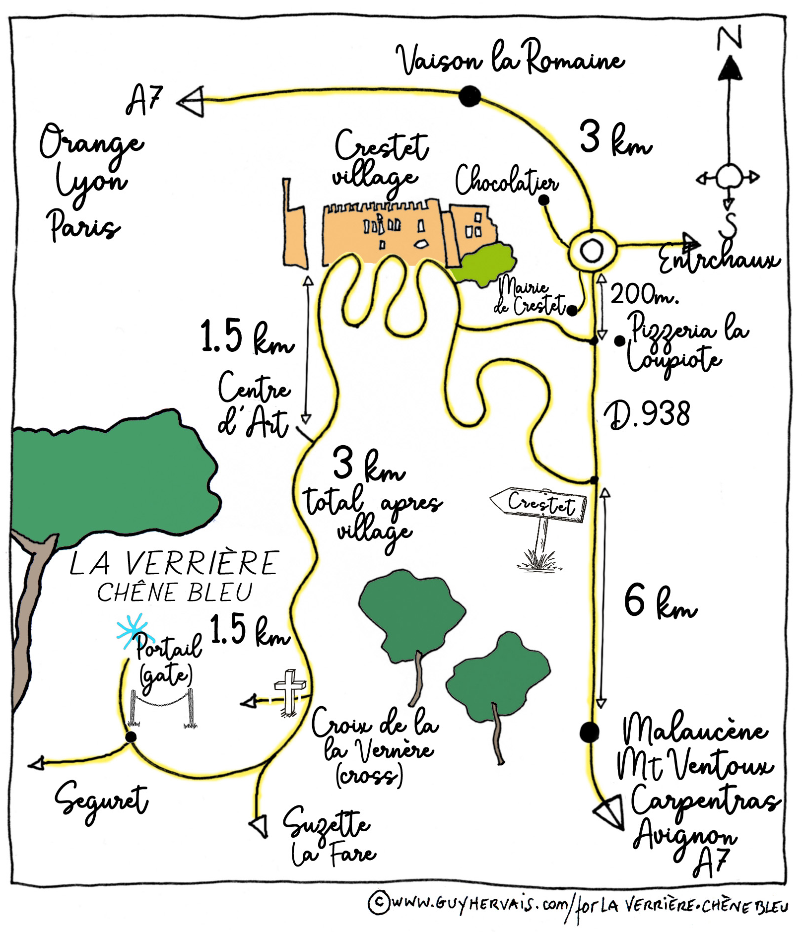
FROM VAISON-LA-ROMAINE: On the D938, turn RIGHT in front of the Pizzeria La Loupiote and head up the mountain on the winding road towards the hilltop village part of Crestet.
FROM MALAUCENE: The turn for Crestet is sooner, on your LEFT.
There are directional signs for Chêne Bleu/La Verrière at the base of the village and at the village.
The road zigzags past the village (do not actually enter the village).
AT THE TOP OF THE VILLAGE: Follow the sign for Chêne Bleu/La Verrière and head LEFT. Drive 3km after the village zigzagging for about 7 minutes through the woods, staying on the ONLY PAVED ROAD. This will bring you directly to us. You will not see many other houses after Crestet until you get to us. It is the right road!
(More details if you want them: After 1.5km you will pass a building below you on the left that used to be the Crestet Centre d’Art. After another 1.2km through the woods, you will pass a big cross: bear right, still on the only paved road, you are almost there! You will eventually see a big clearing in the trees, then the property, surrounded by a sea of vines, and welcome signs for Chêne Bleu & La Verrière).
BUZZ AT THE GATE: PRESS and HOLD the Chêne Bleu or La Verrière call button, we will let you in. Or call us on +33 490 100630. Head to the “PARKING VISITEURS” area, we will welcome you there.
You can download and print these directions and a map here.
We also have an on-site charger for electric vehicles.
by truck
There is no access for trucks over 3.5 tons (weight can be up to 5.5 tons depending on the length- please contact the Winery on +33 4 90 10 06 30, or reservations@chenebleu.com, to check with us)
For trucks exceeding 5.5 tons please contact us on +33 4 90 10 06 30 or reservations@chenebleu.com to make alternative delivery arrangements.
By Plane OR TRAIN
Closest airports: Marseille (1h30min), Nîmes (1h15), Avignon (private planes - 55min)
Or fly to Paris CDG and take the TGV from the airport, or the Eurostar/TGV to Avignon TGV station (there are two train stations in Avignon)
Best train station: Avignon TGV (1h05min)
Other (local) train stations nearby: Orange (42min), Avignon Centre (1h) and Carpentras (40min)
You can ask us for advice for travel from abroad, local taxis etc: reservations@chenebleu.com.
BY HELICOPTER
Our on-site private helipad is accessible by prior arrangement with the French military authority in Orange and then with us. We are happy to offset the carbon footprint for you in association with ForestPlanet.